Tour Package: Byala - Bulgaria
Posted by : BGadmin@ecotournet.net on 23.Nov.21
Last update by : BGadmin@ecotournet.net on 04.Dec.21
SUGGESTION
for sample travel packages
by project
ECOTOUR-NET / DEVELOPING ECOTURISM NET IN BLACK SEA REGION /
The developed routes are suitable for cycling and hiking.
The tourists who could be offered are the following, but not only:
• external tourists
• residents and guests of the town of Byala and Shkorpilovtsi resort
• owners of apartment holiday homes in the town of Byala and Shkorpilovtsi resort
• tourists accommodated in the town of Byala, Shkorpilovtsi resort
• all interested
1. Two-day tourist package town of Byala - Shkorpilovtsi Resort - town of Byala
Suitable for cycling and hiking. The tourists who can be offered are the following, but not only:
• external tourists
• residents and guests of the city
• owners of apartment holiday homes in the city
• tourists accommodated in the town of Byala
The route is suitable for cycling and hiking and is characterized by favorable conditions of the route and sections with a higher load for lovers of extreme experiences, with a wealth of natural attractions, flora and fauna in the surrounding forests, fields, agricultural areas, water and river areas, a dam and the existing infrastructure. The light terrain and the well-chosen route show beautiful panoramic views, forests and fields, and your trip will reach one of our best beaches. Along the route there are plenty of fountains and access to places to eat, as well as 4 places for recreation and picnics.
First day
1. First route point - the center of the town of Byala is the starting point, where there is an information board and a public stand for repairing bicycles with tools and opportunities for food and water supply from nearby shops.
Photo 1- Starting point Byala
2. Second route point - Municipal Cultural Institute / Museum / - Byala
The museum is of interest because it preserves the material cultural and historical monuments found during the archaeological excavations of Cape St. Athanasius - Thracian cult center, including 120 cult pits, furnaces, dozens of sacrificial hearths and a temple, marble statuettes found in the sanctuary of Heracles from the Roman period of the archaeological site. The exposition "Byala and the Sea" is presented in which are presented: amphorae, amphora seals, vessels for consumption of fish - ichthyos, vessels for preparation and storage of fish, fishing accessories, and the permanent exposition includes materials from the VI century BC - finds from the Thracian cult center, from the early Christian sacred center on Cape St. Atanas. The White Rocks Natural Science Exposition is arranged in the Demonstration Center and presents exhibits in several main sections: geology, archeology and paleontology, dating from the Cretaceous / Tertiary period.
3. Third route point - the Ethnographic Complex - Byala
It is recommended the lovers of cultural, ethno-cultural, creative and thematic tourism to visit the Ethnographic Complex in Byala to enjoy the exhibited over 300 exhibits from the municipality - handicrafts, traditional for the region - knitting, weaving, tailoring, tannery, tailoring, cooperage, agriculture, animal husbandry, fishing, viticulture, traditional room, clothing. The exposition gives an idea of the rich diversity in the life and culture of the population of the municipality in the last years of the XIX and the beginning of the XX century.
Starting from the square and following the markings, cross the main road, up through the industrial zone and the Farmyard and reach the highest point of the first, albeit short ascent. Nearby is the wine cellar "Chateau Polychronovi", where cyclists can return again as fans of good wine for tasting and shopping.
4. Fourth route point - Winery"Chateau Polychronovi" - tasting
The route crosses the main road Varna - Bourgas and continues along the route of the interpretive route "Enika". The route passes along a wide dirt road through a suburban agricultural area with arable land and vineyards, climbs to the top of a hill overlooking the bay of Byala and the sea and then heads to the nearby wooded ravines with the river and dam "Enika".
5. Fifth route point - Ecopark Enika
A short break in the eco park, which offers excellent conditions for fishing, rest and relaxation amidst the tranquility and beauty of the surrounding nature. The forest, the river and the dam with their diversity are attractive not only for cyclists, but also for lovers of hunting and fishing tourism, photo tourism, eco-tourism, hiking, cognitive tourism.
Photo - Eco Park Enika
After this lowest point, the route begins to climb, and after a kilometer it reaches a small ridge with agricultural levels and a T-junction. The route continues its smooth ascent and after about 3.4 km there is a place to relax with a table and chairs. About 200-250 m further on the left side you can see the Hunting Hut and the Yurta Fountain. Then continue through the field, cross the main road Varna - Bourgas and continue along the banquet until entering the village of Goritsa.
6. Шеста маршрутна точка - гостилницата “При Панчо“- с. Горица - за обед и почивка. Ако сте прегладнели може да се хапне вкусно в гостилницата “При Панчо”, а съвсем близо до маршрута може да се посети църквата „Св. св. Константин и Елена“, както и да се освежите на селската чешма.
6. Sixth route point - the eating house "Pri Pancho" - Goritsa - for lunch and rest. If you are hungry you can eat deliciously in the eating house "Pri Pancho", and very close to the route you can visit the church "St. St. Constantine and Helena ”, as well as to refresh yourself at the village fountain.
The route continues on the main road in the direction of Varna and immediately after leaving the village it turns through a lined oak forest to the right on a dirt road, which after 1.3 km goes to a place for recreation.
Photo Resting place - land in the village of Samotino
From there you have to cross the field to the nearby forest, passing under the power line and continue the descent to the village of Samotino, known as the smallest village in Bulgaria. At one end there is a picnic area, from which in the distance you can see the beach of Shkorpilovtsi, and nearby, but slightly off the route there is a fountain. Passing through the village is done with two left turns. 2.2 km west of the village of Samotino, you can visit the discovered finds of a late antique fortress. The potential of the site is unused and unknown to tourists and it is necessary to take measures for its exposure, protection and inclusion in sightseeing tourist routes.
After leaving Samotino there is a pleasant descent through a tangle of forest roads. The markings must be followed carefully, but even if they go wrong, all roads lead to the outskirts of the village of Shkorpilovtsi. Upon reaching the asphalt, the route continues to the right, passing through the villa zone "Ticha". Cyclists have another opportunity - to go to the center of the village, where they can eat in a restaurant, to recover their supplies from the shops or to see the church "St. Petka".
Photo - Shkorpilovtsi beach
The route crosses the villa zone "Ticha" on the bypass road, passes by the hotel complex Eco Park Shkorpilovtsi, continues along a shopping alley along the borders of the hotel complex "Long Beach Resort and SPA", descends to the coastal shopping alley and continues to the resort complex "Panorama". Here is the end point of the route for the first day, a separate place for recreation has been created and a marking and information board has been placed.
7. Seventh route point of Shkorpilovtsi resort - rest, dinner and overnight
Photo - Holiday complex Panorama
In the village and the resort area next to it there are 76 categorized places for accommodation - 18 guest rooms, 2 family hotels, 7 guest houses, 29 bungalows, holiday village Zora, 2 hotels and a holiday resort. At the eastern end of the village next to the beach there are 2 hotels and the five-star hotel complex "Long Beach Resort", recreation center, children's camps, holiday villages, beach restaurants and entertainment, shops. 63 restaurants and entertainment establishments with a total capacity of 3833 seats are categorized. Near the village and Shkorpilovtsi resort there is a new sports base with an open stadium - at the exit of the village of Staro Oryahovo.
Places for accommodation in Shkorpilovtsi Resort, awarded on booking sites are:
• Long Beach Resort and Spa
• Eco practice Shkorpilovtsi
• Sea mood
• Villa Adrian
• Hotel Escana
• Jordash Hotel
• The White Swan
• Bungalows Romance
• Bungalow Paradise
• Bungalows Ogosta
• Bungalows Sea dunes
• Camping Shkorpilovtsi
• Holiday complex Panorama
Second day
1. First route point - Late antique fortress near Shkorpilovtsi beach
Archaeological finds have been discovered next to Shkorpilovtsi South Beach and there still is a process of research and restoration of finds from the Late Antique Fortress (Quadriburg), the Early Christian Basilica and Tomb, as well as part of the Old Bulgarian Wall is underway.
On the central beach Shkorpilovtsi, near the last route point of the Red Route, there is a windsurf and kitesurf school Campo. The place is a real place for surfers due to the local thermals. Ideal conditions for beginners and advanced - constant crosswind, which favors sports - in the morning for beginners, and in the afternoon - for advanced. The school has modern surfing, windsurfing and kite equipment, catamaran, motor boat, lake board.
2. Second route point - Shkorpilovtsi beach - optional for rest and free time:
· Campo School - Shkorpilovtsi beach - windsurfing, kitesurfing or beach time lesson
· SPA center Kelara - spa center, sauna, steam bath, Turkish bath, indoor aquatonic and swimming pool, fitness center
· Restaurants - on the beach promenade and in Long Beach Resort
Photo - Camping Shkorpilovtsi
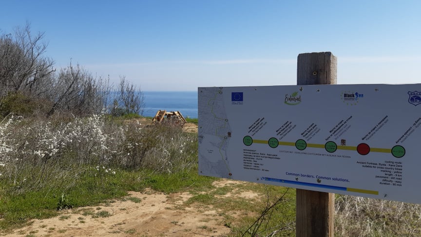
After lunch - departure: Of course, to make it more interesting and to finish the ride at its starting point, from Shkorpilovtsi-Camping Panorama you can follow the connecting marked section to one of the last wild beaches - that of Kara Dere. Then begins the coastal route, which returns to the town of Byala and ends at the entrance to the ancient fortress. In this way a circular route is made and wonderful sea views are added. The route Shkorpilovtsi-Karadere-Byala is a charging adventure, full of sea views from different heights and places. The panoramas along the route, the several places of view and especially the bird watching tower will leave you breathless and so on until you reach imperceptibly from the emblematic wild beach of Karadere to the town of Byala. Due to the short length and relatively small displacement, riding is suitable for beginners. However, having some short but steep sections can be a challenge, but also a chance to train your cycling technique.
3. Third route point - Kara Dere
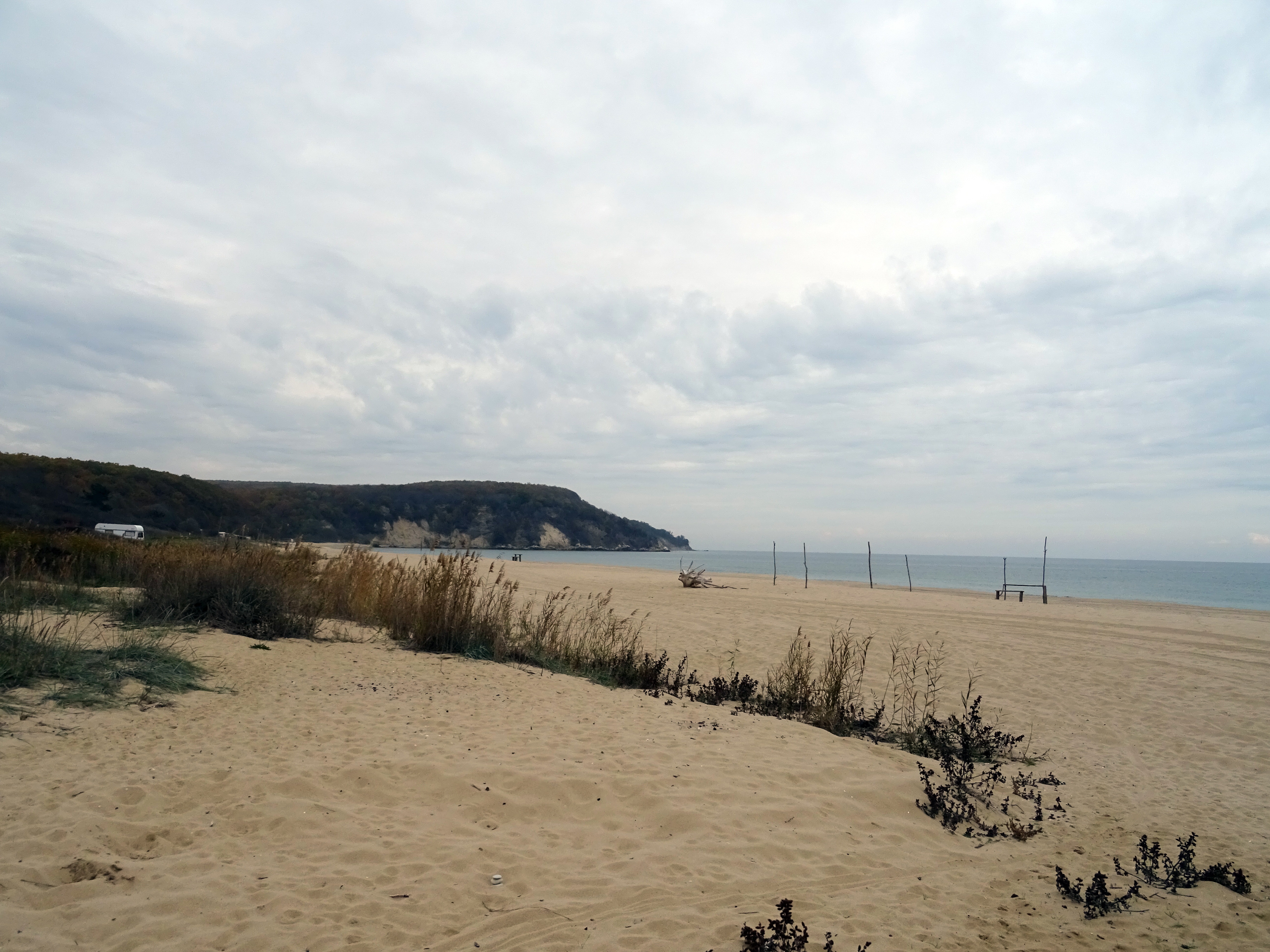
Photo – Kara Dere
Kara Dere beach is one of the longest beaches on the Bulgarian Black Sea coast. The route runs parallel to the beach, which in places borders a forest, elsewhere with bushes. After 1.4 km you reach a small parking lot-meadow with a place for recreation, where the road to the right, then to the left crossing the river. Nearby is the fountain "Alexa", and after about 650 m you will reach a place for recreation White River, located near the natural landmark White Rocks.
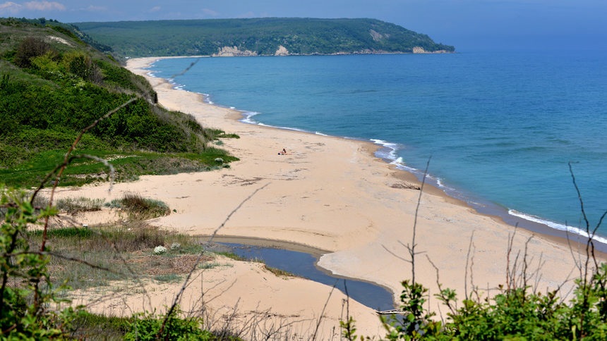
Photo - Byala Reka beach
4. Fourth route point - White Rocks
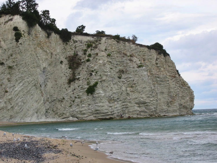
Photo – White Rocks
We have reached the area of natural landmark "White Rocks". The natural landmarks "White Rocks" have a total area of 14.5 ha. 65 million years ago (Cretaceous / Tertiary) a meteorite collided with the Earth (in the Gulf of Mexico) and caused the extinction of dinosaurs. At that time, the territory of today's town of Byala, located 10,000 km from the site of the collision, was at the bottom of a large sea at a depth of about 300 meters. Today, already above sea level, the White Rocks are one of the four places in the world (and the only one available) that testify to this cataclysm. The rocks have a high content of clay, colored in light gray, in places almost white, with imprints of marine life and algae, slightly curving, forming small bays.
5. Fifth route point - Bird Watching Tower
The Bird Watching Tower rises next to the natural landmark White Rocks. The tower is a two-storey wooden building with a total height of 8.16 m compared to the terrain. The access to the floors is through wooden steps, which overcome the displacement between the levels. The building is open, without a roof. The wooden columns in the corners of the tower are positioned on single reinforced concrete foundations. The security on the levels is with wooden railings with a height of 1.10 m. From the bird watching tower there is an incredibly beautiful panoramic view of Cape St. Athanasius and the Black Cape. This is where the Via Pontica flyover passes, one of the main routes for bird migration from Europe to Africa. Observations can be made at any time of the year. Spring is a very favorable season. The flights are mainly in the morning, and in some species at night. Excursions in the early morning under the guidance of experienced connoisseurs are recommended. From the tower can be observed the fields of the typical red-backed shrikes, black-backed and oriental stonecrops, hooded cormorants, alpine swifts, pink starlings, thick-beaked and short-toed larks, cranes. It is recommended that the initial observations be made under the guidance of an experienced expert observer. Fans of photo tourism can choose the right time and desired weather conditions for capturing natural landscapes. Light, depth and location of objects and weather conditions are essential for landscape photography. The intensity, color, and direction of light change due to factors such as different hours of the day, seasons, humidity, angle of sunset, cloud condition, and geographic location. The place is conducive to the use of the most important elements of landscape photography - depth, application of the technique of wide angles and the formation of a dramatic foreground.
Photo - Bird Watching Tower
6. Sixth route point - Cape St. Athanasius and its late antique fortress
Late antique fortress on Cape St. Atanas in the town of Byala is the last point of the route. The valuable archeological find is from late antiquity and the Middle Ages. The discovered remains are of high archaeological and historical significance - an early Christian sacred center, a city bath, a central street, 30 buildings with various purposes, production facilities, three wineries and kilns for household ceramics. In the southern part of the fortress can be seen the lighthouse at Cape St. Athanasius, turned into a tourist attraction in the area of archaeological excavations.
Photos- Late antique fortress at Cape St. Athanasius
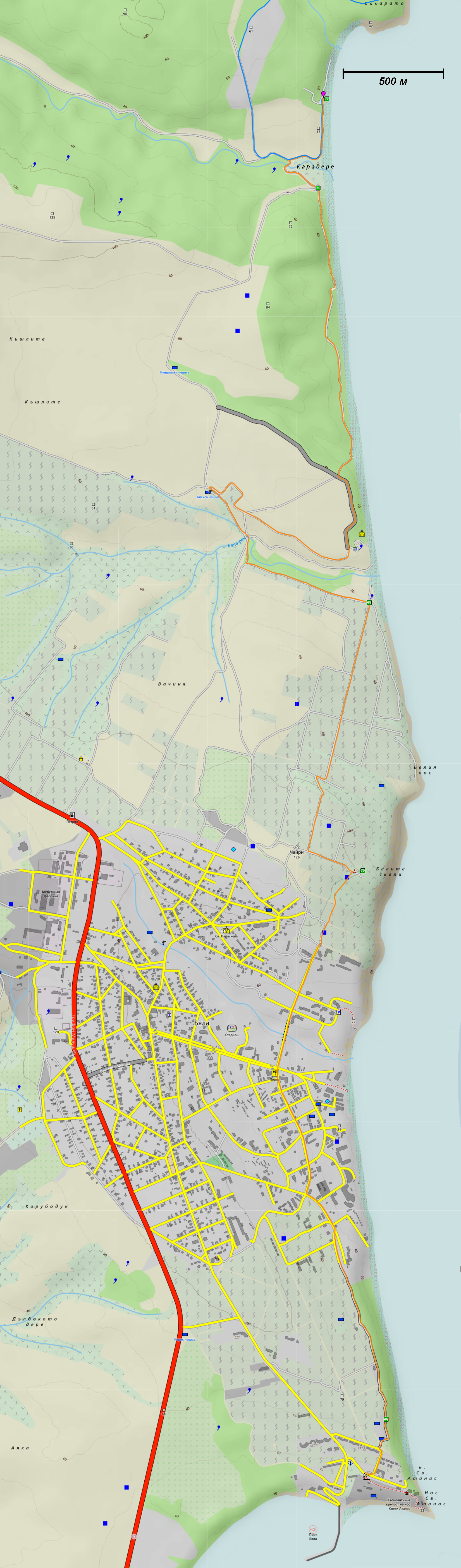
Route Byala - Shkorpilovtsi – Byala
https://www.alltrails.com/explore/map/byala-shkorpilovtsi-gpx-2f3c6a4?u=m
Marking: red, blue, yellow | Altitude: from 1 to 210 m |
Length: 36,33 км | Difficulty: 2 out of 5 |
Climbs: 647 м | Technical difficulty: 2 of 5 |
Descents: 706 м | Fountains 5, Recreation: 9 |
QR code

https://drive.google.com/file/d/1FlRKUnnVztTduA57L1Rpg-gLXM3hJmOn/view?usp=sharing
"Cartography from BgMountains.org"
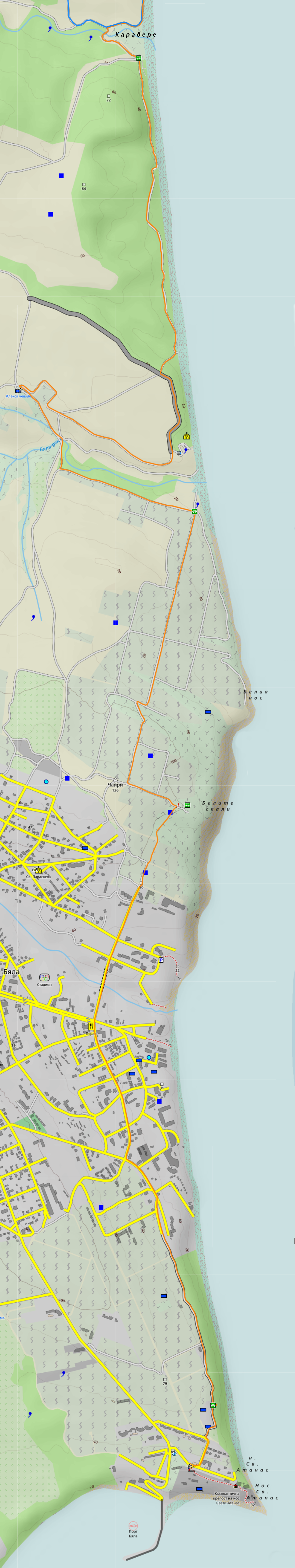
1. One-day tourist package Ancient complex Byala - Kara dere – townof Byala
The route Byala - Kara Dere - Byala is a charging adventure, full of sea views from various heights and places. The panoramas along the route, the several viewpoints and especially the bird watching tower will leave you breathless and so on until you reach the iconic wild beach of Karadere. Due to the short length and relatively small displacement, riding is suitable for beginners. However, having some short but steep sections can be a challenge, but also a chance to train your cycling technique. The route is characterized by favorable conditions of the cycling route, the incredible combination of vast fields, vineyards, wooded areas with beautiful, rocky seashore and views of the vast expanse of sea. The historical, archeological, cultural and ethnographic riches of the territory are a prerequisite for creating unforgettable experiences and a high cognitive effect.
1. First route point - the late antique fortress on the cape "St. Atanas ”- town of Byala
The late antique fortress on Cape St. Atanas is a valuable archaeological find from late antiquity and the Middle Ages. The discovered remains are of high archaeological and historical significance - an early Christian sacred center, a city bath, a central street, 30 buildings with various purposes, production facilities, three wineries and kilns for household ceramics. One of the most remarkable sites in the ancient city is the Basilica, located on the edge of the cliff, partially restored. A real place where history has left its mark and a destination worth visiting, revealing a picturesque view. In front of the main entrance there is a large model of the village. The beautifully painted panels present a three-dimensional picture of the village and scenes from its life and stimulate the imagination of the visitor. In the southern part of the fortress can be seen the lighthouse at Cape St. Atanas, turned into a tourist attraction in the area of archeological excavations.
Photos- Late antique fortress at Cape St. Athanasius
Going north from the Late Antique Fortress, we can not fail to mention a few interesting places. Between the cape of St. Atanas and the town of Byala is a small bay where the sea throws algae with a characteristic pungent odor. Hence its name - Kokar - Kokar - fragrant. Here are the Todor stones - rocks that are dangerous in stormy seas because they are difficult to see. Legend has it that the boat of Todor, a fisherman from Byala, who drowned in the accident, turned here and that is why they are called Todor's stones. Continuing along the route we pass through Shami beach, above which there is a small cape - Shen Kurun, which ends a hill on the Kamchia Mountains. One of the meanings of the ancient Greek verb "συγ- κυρέω" is "border, I am a neighbor." Along the route we pass to Glyko - the mouth of the stream passing through Byala, forming a small freshwater lagoon. According to the legends of the first Greek settlers in the area, who came down to the mouth of the stream, the water was so sweet that they called the place "glyco" - "sweet".
Of interest among the sites in the town of Byala are the nearby cultural sites of regional importance - the Old Churches in the town of Byala - "St. Venerable Martyr Paraskeva - the oldest church in the municipality, the Church of the Assumption of the Blessed Virgin, the Chapel “St. Atanas ”- defined as the oldest Christian center in the land of Byala.
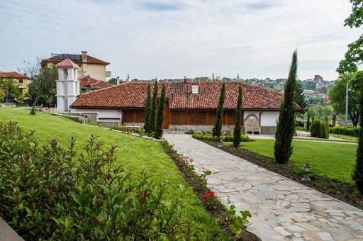
Photo - Church of St. Martyr Paraskeva
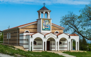
Photo - Church of the Assumption of the Blessed Virgin
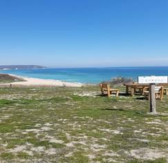
2. Second route point - A place for recreation with panoramic views
Shortly before leaving the city, you will cross a large bridge, followed by a steep climb on asphalt and after a short walk on a dirt road you reach the first viewpoint with panoramic sea views, where there is an information board with information about the route. A table and benches made of wood are provided. The place reveals a wonderful sea view and in addition to relaxation can be used for observation and photography of insects and birds, the dance of dolphins, wildflowers and shrubs.
Снимка - Първо място за отдих с панорамна гледка
3. Third route point - Bird Watching Tower
After a short walk we reach the Bird Watching Tower - the third waypoint of the route. The bird watching tower offers an incredibly beautiful panoramic view of Cape St. Athanasius and Black Cape. This is where the Via Pontica flyover passes, one of the main routes for bird migration from Europe to Africa. It is of international importance as a typical "narrow front of migration" for migratory birds - 78% of all white storks (Ciconia ciconia), the entire population of pink pelican in Europe (Pelecanus onocrotalus), Egyptian and griffon vulture (Neophron percnopterus), rare species of imperial eagle, birds of prey, waterfowl and songbirds. Migratory birds concentrate and cross the Balkan Mountains in this part, because it is the lowest and easiest to overcome the barrier. Bird watching can be done at any time of the year. Spring is a very favorable season. The flights are mainly in the morning, and in some species at night. Excursions in the early morning under the guidance of experienced connoisseurs are recommended. From the tower can be observed the fields of the typical for the territory red-backed shrikes, black-backed and oriental stonecrops, hooded cormorants, alpine swifts, pink starlings, thick-beaked and short-toed larks, cranes.
Photo - Recreation area Bird watching tower
The route continues on dirt roads, surrounded by bushes, on steep slopes and desolate lands, numerous beautiful and colorful grassy species. During the transition, typical birds can be observed, inhabiting the settlements and villa areas. After the Tower, the route continues a little higher (west) and after 240 m turns right, starting the descent. After about 200 m the slope becomes quite large, and due to the terrain and some sharp turns it is not recommended to raise high speed. After the three sharp turns the road is only straight, passes through large vineyards - as far as we can see we see vast areas planted with vineyards - Saye Ambeli - Saya ambeli - the vineyards around the Saya.
4. Fourth waypoint - White Rocks
We have reached the area of natural landmark "White Rocks". The natural landmarks "White Rocks" have a total area of 14.5 ha. 65 million years ago (Cretaceous / Tertiary) a meteorite collided with the Earth (in the Gulf of Mexico) and caused the extinction of dinosaurs. At that time, the territory of today's town of Byala, located 10,000 km from the site of the collision, was at the bottom of a large sea at a depth of about 300 meters. Today, already above sea level, the White Rocks are one of the four places in the world (and the only one available) that testify to this cataclysm. They represent a two-kilometer continuous rock geological profile, in which the two consecutive Cretaceous / Tertiary periods are clearly read. The rocks have a high content of clay, colored in light gray, in places almost white, with imprints of marine life and algae, slightly curving, forming small bays.
Photo - Natural landmark "White Rocks"
5. Fifth route point - a place for recreation with panoramic views of Byala Reka
In minutes the road leads us to a place for relaxation with panoramic views, which is only 70 meters from the sea. On a wide meadow there is a place for relaxation with a beautiful panoramic view overlooking the beach Kara Dere, perhaps the last nice, really wild beach, and one of the longest beaches on the Bulgarian Black Sea coast. Here you can take panoramic photos and take a short break before the upcoming descent to the gully of Byala Reka.
The place is suitable for relaxation, picnic, cooking on the grill and lunch. Table and benches made of wood are provided.
Photo - Recreation place Byala Reka Beach
After the resting place you should take the road on the left, and after 650 m you should turn right on the road passing through the gully. Shortly before it climbs completely, on the opposite slope on the left is the only Alexa fountain along the route, but you should not rely entirely on it, as it dries up in dry periods.
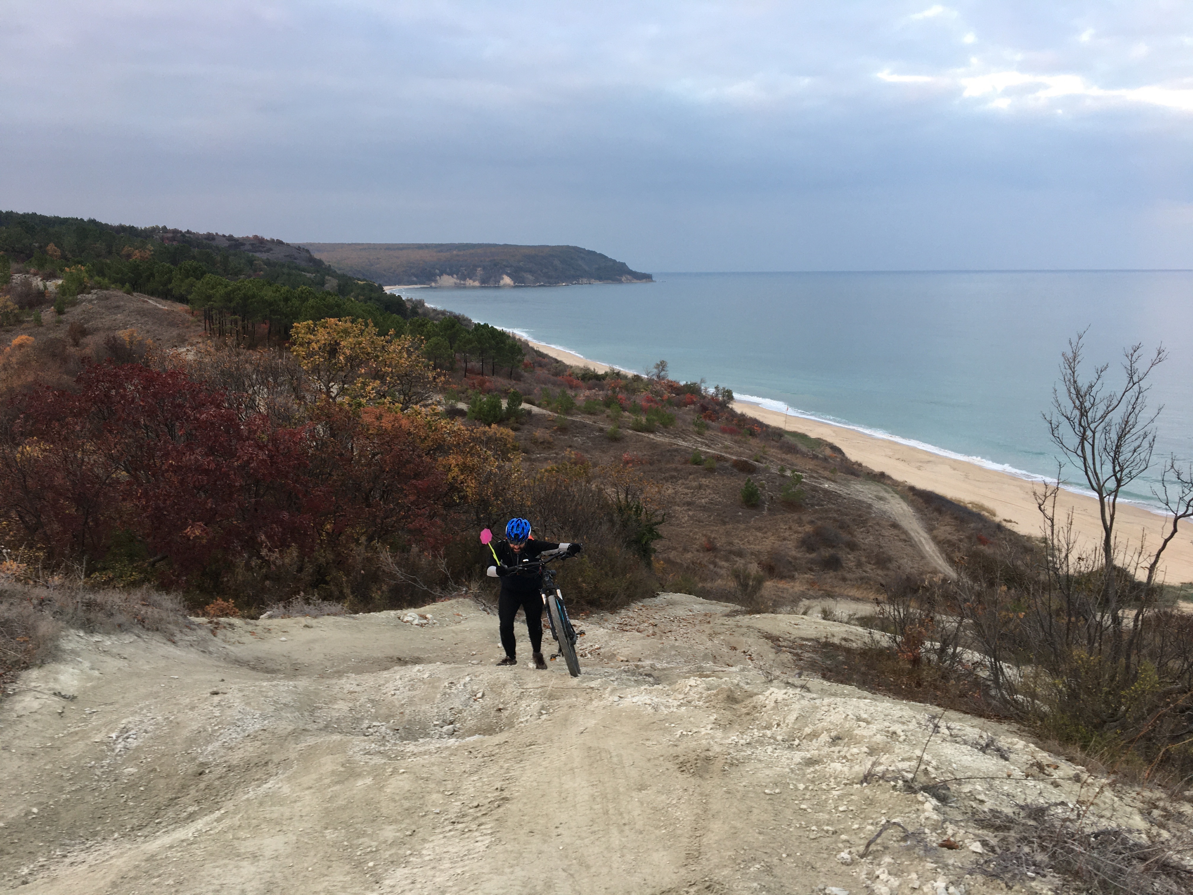
Photo - Steep climb
A few meters from the Alexa fountain, there is a fork where you have to make an almost U-turn to the right and drive at the end of the field, go around an orchard and then again at the end of the field you will reach a section that runs parallel to the sea. 50-60 m after reaching a smooth left turn, you should take the road to the right, which descends to the beach. It is steep and quite technical, so it requires a lot of attention! After going down, continue along the path parallel to the sea. It has slight ascents and descents, and the coniferous trees and the landscape are very reminiscent of the Mediterranean. After 1.4 km you reach a small parking lot-meadow with a place for recreation, where the road turns left, then right crossing the river. Then again to the right to the sea and after 460 m you reach the information board on the beach, where the end of the route and you can find the last place to relax. If you use mobile navigation devices, keep in mind that there is no range in the Karadere area.
6. Sixth route point - Kara Dere Beach
Kara Dere beach is one of the longest beaches on the Bulgarian Black Sea coast. The route of the route runs parallel to the beach, which in places borders a forest, elsewhere with bushes. The characteristic psammophytic vegetation can be observed on the sandy beaches and dune complexes, which includes both open grass phytocenoses, with sparse vegetation near the shore, and grass communities of the stabilized dunes.
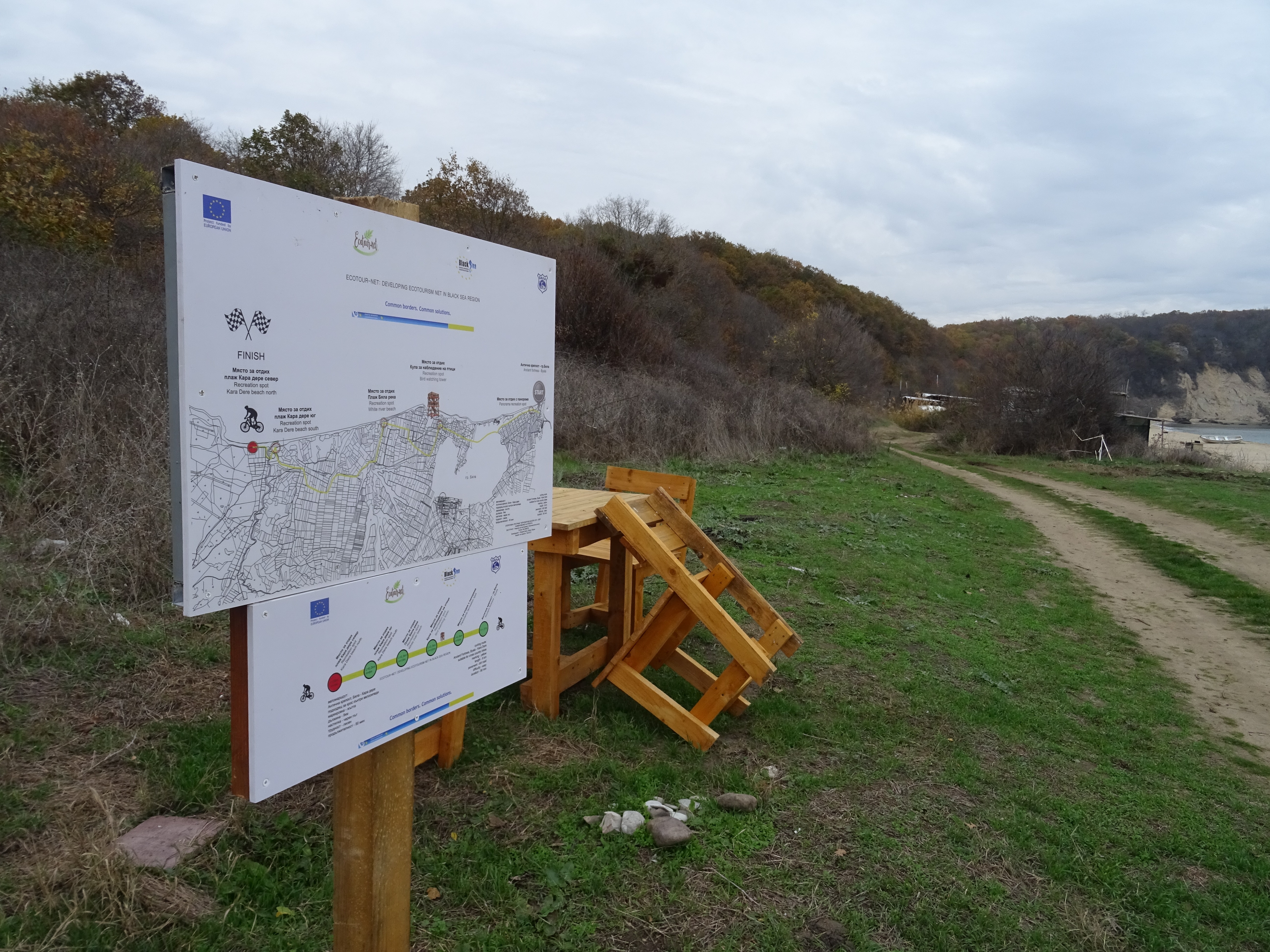
Photo - A place to relax Kara Dere beach north
The wonderful natural landmarks of the territory suggest increased interest in the route by lovers of photo tourism, eco-tourism, hiking, cognitive tourism, scientific and thematic tourism.
Marking: Yellow color | Altitude: from 1 to 118 m |
Length: 9.77 km (in the direction) | Difficulty: 1 out of 5 |
Climbs: 206 m | Technical difficulty: 2 of 5 |
Descents: 236 m | Fountains: 1, Recreation: 5 |
QR code yellow route

Embed code:
<iframe class="alltrails" src="https://www.alltrails.com/widget/map/gpx-eb9fc34?hideName=true&u=m" width="100%" height="400" frameborder="0" scrolling="no" marginheight="0" marginwidth="0" title="AllTrails: Trail Guides and Maps for Hiking, Camping, and Running"></iframe>
" Cartography from BgMountains.org"
General recommended information:
The proposed tourist eco-cycling routes could be well offered as walking tourist routes. According to the classifications for the level of difficulty of the pedestrian routes, they are determined in levels between the 1st and the 4th level. The criteria for determining the levels of difficulty are:
• Level 1 difficulty: The total walking period does not exceed two hours. The paths are wide and the step is low. These are convenient paths for straight walks.
• 2nd level of difficulty: The walking period is not more than 3.5 hours, and the distance along the slope of the paths does not exceed 300 meters.
• 3rd level of difficulty: This level is designed for sloping paths with a slope of up to 500 meters on routes that can take a total of 5 hours. These paths have sections with narrow paths, wet transit areas and wooded lands.
• 4th level of difficulty: This level has a sharper slope. Its slope distance, on the other hand, is about 700 meters. They are 6.5 hour hiking trails that try challenging trails, dense and rocky areas.
• 5th level of difficulty: It is strongly inclined and the distance of its inclination reaches 1000 meters; the performers walk on challenging terrains such as dense forests and rocky areas, following a certain route. Lasts about 8 hours. For this reason, the support of a professional guide is required.
• Level 6 difficulty: These are long-distance walks that require 8 hours or more and are often supplemented by accommodation. The distance on the slope can reach 1500 meters, on this trail there are difficult conditions on land and frequent slopes.
Requirements for clothing and equipment are most often reduced to the following:
· The mountain bike is indicated as a recommended means of transport on the proposed routes. This is a type of bicycle that specializes in such terrain and is therefore most often used due to the good level of balance and handling, good traction, wide range of gears and softer ride.
· Clothing - covering the upper body, made of strong, easily drying materials, preferably synthetic, hat.
· Shoes - hiking shoes, closed, strong, light, soft, well ventilated, made of faux leather or fabric, with strong and dense soles. It is also appropriate to use cycling shoes.
· Equipment - backpack up to 20 liters with the essentials, without unnecessary items, sports water bottle or backpack bag, compass, first aid kit, pocket knife, headlamp, headlight, navigation device, spare two tires and repair set.
· Requirements for technical safety - it is preferable to use a mountain bike in good technical condition, helmet and gloves.